English
 Español
 Français
 Deutsch
 Italiano
 Português
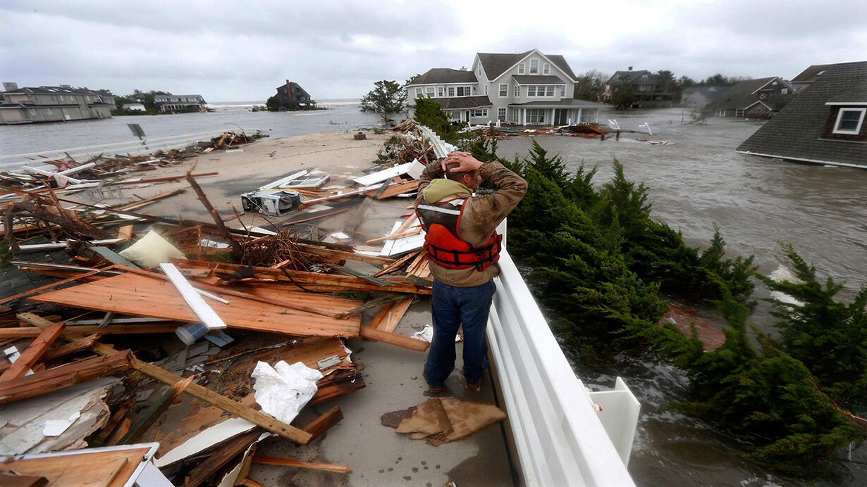
The following is a brief story about how our family experienced Hurricane Sandy. It was the 29th October 2012, at 9pm, in New York City. Our apartment was located at 301 West 57th Street, number 23G.
Donata, my Italian wife, Maya, our five-year-old granddaughter, and I decided to go to bed early after hamburgers at the diner on Eighth Avenue. With no TV in our small Manhattan apartment, we bought a handheld radio from Radio Shack to keep up with events. We kept it centrally located on top of the refrigerator, although it did not always stay on the stations. There was this howl coming from outside our bay window. The wind seemed to growl, and we could not hear the radio clearly, so I finally turned it off.
Our bay window faced the stunning Hurst Building remodeled by Norman Foster, but we were afraid to look at it now. We had closed all the window blinds and curtains to stay in our little ‘cocoon’ of an apartment and, more importantly, to protect ourselves from the possibility of a shattering window. I was not worried about the building; it did not seem to sway. I could feel no movement. But window frames rattled, and we could feel the pull of the gusts outside. We were scared. The glass panes must have bent ever so slightly.
We had two single beds, and Maya bravely proposed to try to sleep on her own inside a small tent we assembled next to the table. In the tent, she was slightly nearer the windows, but the tent gave her extra protection in case there was flying glass, more safety than we had in the two single beds, naturally with us grandparents under the covers. Maya was excited by a sense of adventure and eagerly went into her tent. Anxiously I turned off the lights. The wind howled and growled. We slowly went to sleep. We didn't hear the windows that did ‘pop-out’ on the upper floors of our building.
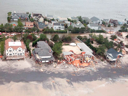
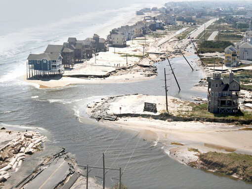
In the morning, the wind had died down, and we ventured out. There was a fascinating dangling construction crane further down our street, not far from Carnegie Hall. It was on top of the building, moving with the wind. Firemen were busy roping off the blocks as they feared the crane would crash down onto the street, cutting into the gas line and exploding. We telephoned friends living in lower Manhattan to discover that their apartment was without electricity, and they had taken an emergency hotel room. We had just been through the storm surge of Hurricane Sandy.
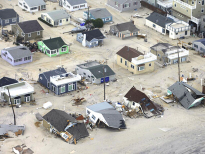
The storm flooded streets, tunnels, subway lines and cut off power in many parts of the city. The East River overflowed its banks, flooding large sections of Lower Manhattan; Battery Park had a water surge of 13 ft.; seven subway tunnels under the East River were flooded. Seawater flooded the Ground Zero construction site, and thousands of flights were canceled. “Wind, rain, and water destroyed approximately 300 homes, left hundreds of thousands of New Yorkers without power, damaged critical public and private infrastructure, and left many New Yorkers vulnerable with limited access to food, drinking water, healthcare, and other critical services. The City of New York’s preparation and immediate response to Hurricane Sandy was one of the largest mobilizations of public services in its history… The storm resulted in the deaths of 44 city residents and inflicted an estimated $19 billion dollars in damages and lost economic activity across New York City. Most significantly, over 69,000 residential units were damaged, and thousands of New Yorkers were temporarily displaced.”1 Fifty square miles or 17 percent of the landmass was flooded.
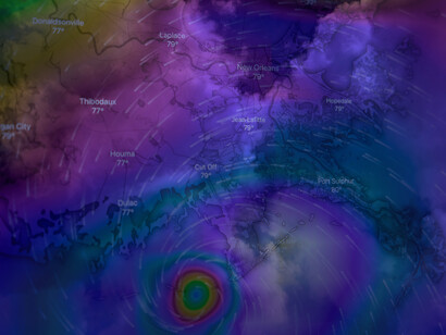
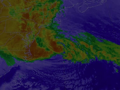
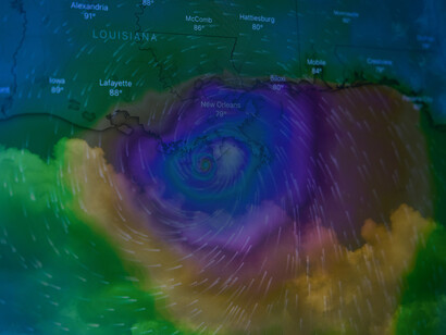
Experts agree that the storm was caused by “natural variability” but that it was “enhanced by global warming.” “One factor contributing to the storm's strength was abnormally warm sea surface temperatures offshore the East Coast of the US — more than 5°F above average, to which global warming had contributed 1°F.2
Building resilience in New York City
“The Disaster Relief Appropriations Act of 2013 provided emergency relief funding to multiple Federal agencies in order to assist in the recovery efforts. As part of this legislation, New York City received roughly $4.2 billion dollars in Community Development Block Grant - Disaster Recovery funding to address a range of needs, including rebuilding and rehabilitating housing, assisting displaced tenants, providing aid to businesses, and bolstering coastal defenses.”1
“The City's coastal resiliency projects are focused on reinforcing the shoreline in certain low-lying neighborhoods to mitigate the impacts of sea level rise, storm surge, and erosion. This includes developing berms, levees, raised shorelines, wetlands restoration, and other innovative measures to mitigate existing or future flood risks.”1 The five areas of focus are the Brooklyn-Queens Waterfront, the East and South Shores of Staten Island, South Queens, Southern Brooklyn and Southern Manhattan, including 42,000 businesses and 700,000 residents, with six or seven projects in each area.
The resiliency programs in NYC are impressive for their diversity and accountability. Coastal programs are only part of the overall program that includes the resiliency of buildings, utilities, liquid fuel supplies, transportation, parks, water and wastewater systems. Such aspects as insurance, economic recovery and healthcare are part of the package. Adaptation continues, and the Mayor's Office of Climate and Environmental Justice will release a new plan for climate adaptation in NYC this year.
It is noteworthy that the city has one of the most advanced building codes and is therefore saving energy and greenhouse gas emissions, an essential mitigation to climate warming and eventually reducing the adoption requirements. Now New York City is not considered a market with high climate risk.
Building urban resilience elsewhere
The next question is how the different towns and cities of the US should plan and implement their resiliency. New York has had a unique experience and devoted considerable resources to the problem but does not represent most of the other cities. The matter becomes more complicated as humans continue to migrate. As the effects of climate change grow increasingly prevalent, they become harder and harder to ignore, especially in deciding where to live. The National Resource Defense Council (NDRC) reports that rising sea levels will be a significant driving force in displacing populations globally. The NDRC forecasts that 4.2 to 13.1 million citizens could be forced to move due to climate change by the end of the century, as more land in the US becomes unlivable.
The National League of Cities (NLC), comprising villages, towns, and cities with a total of 200 million residents, constitutes an important voice for strengthening local leadership and influencing policy. The NLC has a unique method for planning for climate change, emphasizing the impacts of climate migration. The method identifies three types of communities: vulnerable cities, recipient cities and climate destinations. “Vulnerable cities are in high hazard areas, and that lack the financial resources to adapt to climate change, may experience varying levels of out-migration due to job losses, economic decline or the inability to rebuild after recurrent disasters due to declining credit ratings.”3
Instead, “some cities, even if not directly affected by a slow or sudden onset disaster, may themselves play host to large numbers of in-state residents seeking refuge. They may be temporarily displaced or eager to resettle, or unable to return to their homes. Recipient cities are typically geographically close to the ‘sending communities,’ but more distant relocations are also common. They are often small or mid-sized cities with their own share of social, economic, or climate-related stressors, including housing affordability. In some circumstances, the recipient city may have been spared the full impact of the immediate disaster but would not be immune from later catastrophic events. In 2005, the city of Houston, Texas, absorbed nearly 250,000 displaced New Orleans area residents after Hurricane Katrina, with an estimated 25,000 to 40,000 people settling there permanently. Years later, Houston itself was at the center of the devastation wreaked by Hurricane Harvey. Nevertheless, a larger city such as Houston may be more equipped to support and resettle larger numbers of incoming residents and could reap economic and cultural benefits from such an influx. Smaller and mid-sized cities could be disproportionately impacted by such an event.”3
Finally, climate destinations are cities that have access to plentiful fresh water, affordable housing, and relative safety from wildfires and hurricanes. The legacy cities of the Northeast and Midwest, once industrial hubs that lost population during urban disinvestment, often have these characteristics. They also possess strong institutions such as universities and hospitals, have abundant parks and pedestrian walkways. For example, recently, cities such as Syracuse and Buffalo, New York, and Duluth, Minnesota, have received significant media attention about their potential to become America’s future “climate havens.”3
The NLC method consists of identifying which of the three types of cities your city belongs to and planning for the local climate risks and likely climate migration. Of course, the three types of cities represent a continuum, and more than one form may be present in the same town, especially large ones. Initial application of the method has shown that many cities (70%) have multiple classifications, about half of the cities are considered as vulnerable, even more (85%) are self-classified as recipient cities, and about one-third (37%) are seen as good climate destinations. The most straightforward way to determine how your city is categorized and adapting to climate change is to consult your city sites.
There are climate information and maps for all of the US counties, and these may provide initial information to better understand your city's primary risks.4
Insurance companies have begun to study additional costs due to climate change. Insurify has published a study of the twenty housing markets most at risk for climate change in the US. It is based on the University of Notre Dame’s Urban Adaptation Assessment, which includes risk calculations for climate change hazards (heat, cold, floods, droughts and sea level rise) and the economic, social, and governance measures in place to combat them in 280 US cities across 48 states, and Redfin’s Housing Market Data, which includes real estate market metrics monthly across multiple geographic levels.
The study concludes, “coastal cities are at the highest risk. Perhaps unsurprisingly, the twenty cities whose housing markets are most susceptible to the effects of climate change are coastal, with the notable exception of Chicago. While Chicago is not on an oceanic coast, it is on the coastline of Lake Michigan, leaving the city susceptible to similar outcomes as cities on an ocean shoreline.” These consequences include flooding, erosion, and saltwater intrusion into surface and groundwaters. In order of increasing climate risk, the twenty markets with the highest climate risk are5:
- Wilmington, Delaware;
- Oxnard, California;
- Fort Lauderdale, Florida;
- Jersey City, New Jersey;
- Downey, California;
- Pomona, California;
- Chicago, Illinois;
- Norwalk, California;
- El Monte, California;
- Garden Grove, California;
- Newark, New Jersey;
- Miami, Florida;
- Elizabeth, New Jersey;
- New Haven, Connecticut;
- Bridgeport, Connecticut;
- Allentown, Pennsylvania
- Inglewood, California;
- Paterson, New Jersey;
- Hialeah, Florida;
- Santa Ana, California.
Instead, a study from the University of Southern California projects that popular cities for relocation may be such inland metropolitan areas as Atlanta, Houston, Dallas, Denver and Las Vegas. The impacts of sea level rise are extensive, expanding beyond coastal areas via increased migration and disproportionately affecting some areas of the US.6
Changing residence is a complex decision based on many factors such as job availability, being near family, housing costs, living expenses and others. Among these factors, the local climate plays a role, and we relocate for all these reasons. I am not too surprised that some trends indicate more home purchases in areas of higher climate risk. For example, people like living near the sea despite all the risks.
Real estate consultant Garry Creath commented, "our workforce is becoming increasingly mobile. Many of our ‘white collar’ jobs can be accomplished from anywhere, and the Covid pandemic has accelerated this. It will spread migration, and to a certain extent, some younger workers may feel they can beat climate change. They can rent anywhere, even with the help of countries with short-term visas encouraging this; they stay awhile until the climate suits them and then move on. Of course, this is the problem; they are thinking only of now.”
In conclusion, climate change is harder to ignore at the local level. We just call it climate. We know it is getting hotter. We understand that water scarcity is a growing problem in many localities because we pay the water bills. If we live near or in a forest area, we have likely experienced the smoke of burning trees. We know where tropical storms are more likely to occur. And we are aware that coastal cities suffer from more flooding, saltwater intrusion, and erosion.
The second deduction is that at the local level, many of us expect (rightly so) that our towns and cities plan for their climate risks. Again, we do not have to call it climate change, but coastal cities and other higher-risk areas must adapt. Minimum protection against heat waves is necessary. Those that cannot adapt may become so vulnerable that few choose to live there. Other areas are safer and may become climate havens. All of this requires planning for change.
And finally, migration due to climate reasons will probably accelerate and should be considered part of the planning process. Potential recipient localities must be aware of the possible migration, climate destinations would prefer to maintain their advantages and must plan to do so, and the vulnerable areas must either be abandoned or adapt. The movement of persons is one of our fundamental freedoms, and we should understand and facilitate it.
Notes
1 NYC Government, The Impact of Sandy, NYC Government site, accessed 03/05/2022.
2 Trenberth, Kevin, (2012) The Conversation. Hurricane Sandy mixes super-storm conditions with climate change. Retrieved October 29, 2012.
3 Marandi, A., Lellani, K., (2022), The Next American Migration: What Cities Should Know About Climate Change and Populations on the Move, National League of Cities.
4 National Center for Environmental Information, (2022), Climate at a Glance.
5 Insurify Insights, (2021), On The Rise: Housing Markets Most At-Risk for Climate Change, July 26.
6 Robinson C, Dilkina B, Moreno-Cruz J (2020) Modeling migration patterns in the USA under sea level rise PLoS ONE 15(1): e0227436.